Landfill Visual Simulation
The following visual simulation is taken from the “Final Environmental Impact Statement” dated August 1998 which was completed during the sitting/permitting process associated with the Regional Landfill. The complete simulation is part of the FEIS.
Background:
Acquisition of Original Site Photographs
On April 13, 1998, The Environmental Collaborative (TEC) and Barton & Loguidice, P.C. (B&L), performed the leaf-off site photography used for the preparation of the Site WLE-5 East visual simulations. Three-foot diameter helium balloons were flown to the height and location of two reference highpoint benchmarks for the proposed landfill landform. TEC then photographed the landfill site from 26 designated viewing stations.
Creation of the Visual Simulation Images
B&L provided TEC with vector based digital files of the topographic data for the proposed landfill landform at 10 years, 20 year and project completion stages of development. The original data was generated by B&L using Intergraph Microstation CAD software. FormZ was used to generate the digital 3D models of the landfill landform because of its strong terrain modeling capabilities. Texture maps were produced by TEC to match the color and general appearance for the landfill site at the time of year represented by the original site photographs. These texture maps were then attached to the 3D models in the areas indicated by B&L as grass-covered or bare soil for each of the four project phases. Tree growth and future plantings which could potentially screen the landfill from view are not taken into account in the visual simulations.
Each of the models was produced to match the scale of the engineering topographic data, while the X, Y, and Z coordinates for the 10 viewing stations selected by the Authority for the preparation of visual simulations were scaled from a USGS 7.5 minute quadrangle map. The latitude, longitude, date and time of day were all set in FormZ to match that of the original site photographs, and 24 bit color renders were then produced from FormZ to match that of the original site photographs, and 24 bit color renders were then produced from FormZ to match: (1) the camera position and lens field of view for the original site photographs, and (2) the DPI resolution of the digital images produced from those photographs. The size and shape of the landform images were thus produced mathematically by the 3D modeling program to match the viewing context of the original site photographs. The images of the landfill landforms for each viewing station were then digitally composited with their respective original site photographic images by TEC using Adobe Photoshop. The landform images were positioned to register with the reference benchmarks represented by the helium balloons in these scenes. TEC then modified the hue, color saturation, and brightness of landfill images slightly to better match the particular lighting conditions of each scene. This was necessary to compensate for atmospheric haze and lighting conditions unique to each original photograph. The resulting simulated scenes represent an accurate graphic rendition of four phases of the proposed landfill landform when placed into the context often existing landscape scenes for the proposed landfill site.
Finished Images of the Proposed Project
The locations from which the photographs were taken are shown on the map below. The finished image products of all original site photographs and the resulting visual simulations provided by TEC are presented beginning with Station 1.
Click on station numbers below to see simulated views of what the landfill will look like over the life of the project.
-
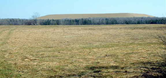
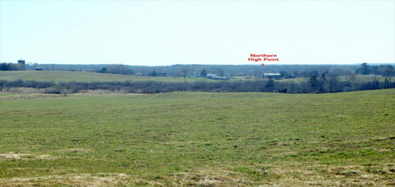
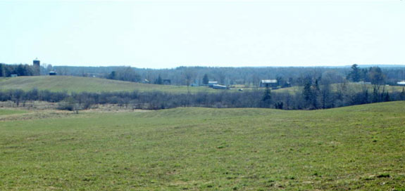
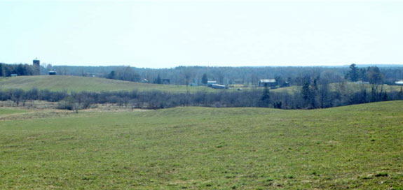
Station 1
-
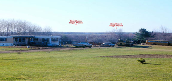
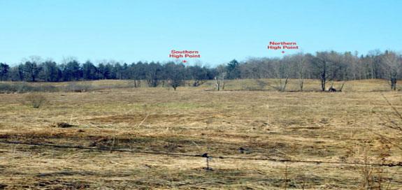
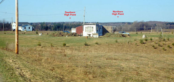
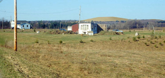
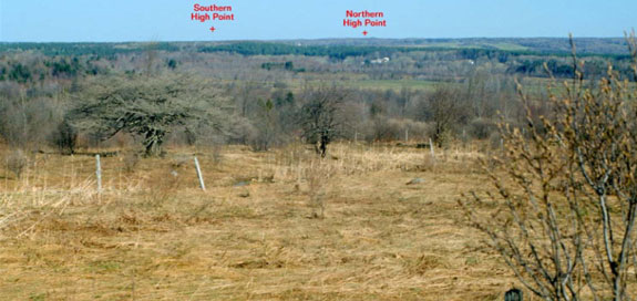
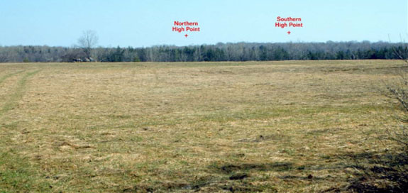
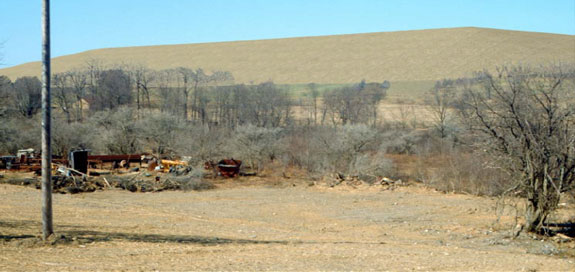
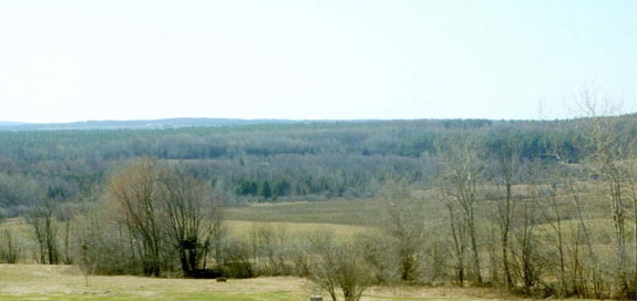
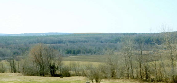
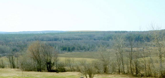
Station 1 (original scene): Original photograph taken on 13 April 1998 (using a 35 mm camera with a 70 mm lens) indicating the position of helium balloons used to determine the location of the northern and southern high points of the landfill landform.
-

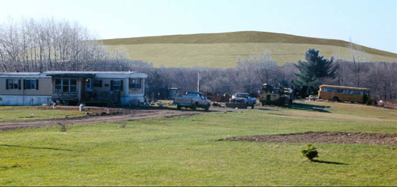
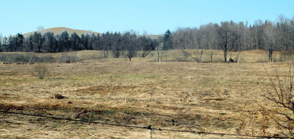
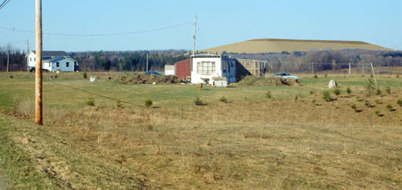
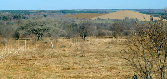
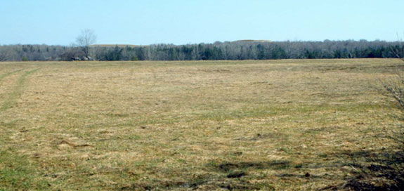
Station 1 (simulated scene): Simulation using the original 1998 site photograph and illustrating the appearance of the proposed landfill landform after 10 years of project operations.
-
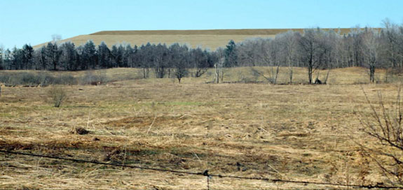
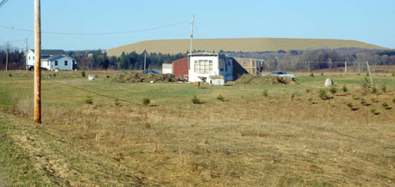
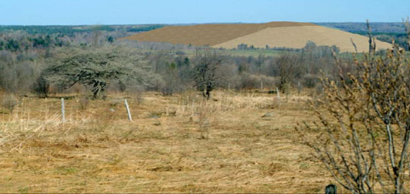
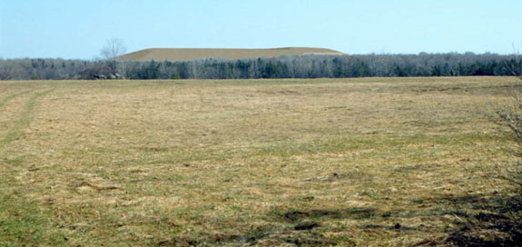
Station 1 (simulated scene): Simulation using the original 1998 site photograph and illustrating the appearance of the proposed landfill landform after 20 years of project operations.
-
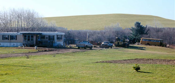
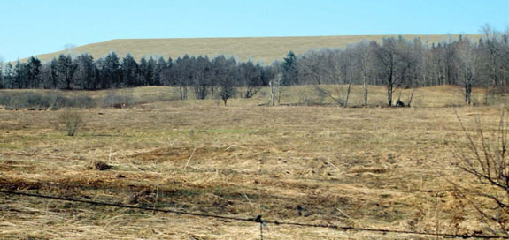
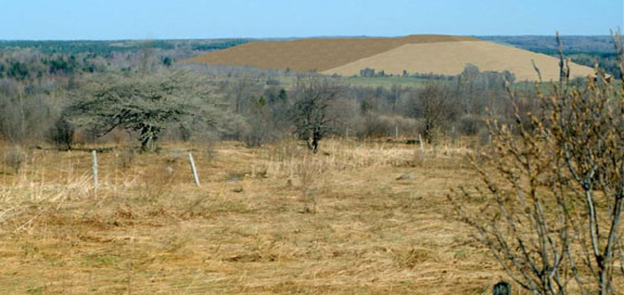
Station 1 (simulated scene): Simulation using the original 1998 site photograph and illustrating the appearance of the proposed landfill landform at the time of the project completion and the closeout of all landfill operations.
-
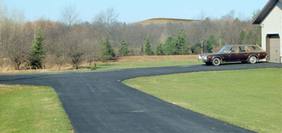
- The simulated scenes for Station 1 are from N.Y. State Route 294 at the approximate location of the proposed entrance to the landfill looking in a southeasterly direction towards the proposed landfill footprint.
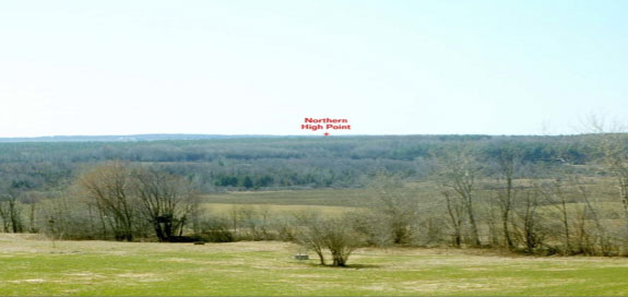
Station 5
-
Station 5 (original scene): Original photograph taken on 13 April 1998 (using a 35 mm camera with a 70 mm lens) indicating the position of helium balloons used to determine the location of the northern and southern high points of the landfill landform.
-
Station 5 (simulated scene): Simulation using the original 1998 site photograph and illustrating the appearance of the proposed landfill landform after 10 years of project operations.
-
Station 5 (simulated scene): Simulation using the original 1998 site photograph and illustrating the appearance of the proposed landfill landform after 20 years of project operations.
-
Station 5 (simulated scene): Simulation using the original 1998 site photograph and illustrating the appearance of the proposed landfill landform at the time of the project completion and the closeout of all landfill operations.
-
- The simulated scenes for Station 5 are from N.Y. State Route 294 approximately 0.4 miles west of Gleasman Road looking in a southerly direction towards the proposed landfill footprint.
Station 7
-
Station 7 (original scene): Original photograph taken on 13 April 1998 (using a 35 mm camera with a 70 mm lens) indicating the position of helium balloons used to determine the location of the northern and southern high points of the landfill landform.
-
Station 7 (simulated scene): Simulation using the original 1998 site photograph and illustrating the appearance of the proposed landfill landform after 10 years of project operations.
-
Station 7 (simulated scene): Simulation using the original 1998 site photograph and illustrating the appearance of the proposed landfill landform after 20 years of project operations.
-
Station 7 (simulated scene): Simulation using the original 1998 site photograph and illustrating the appearance of the proposed landfill landform at the time of the project completion and the closeout of all landfill operations.
-
- The simulated scenes for Station 7 are from East Ava Road at a point approximately 0.1 mile south of N.Y. State Route 294 looking in a southwesterly direction towards the proposed landfill footprint.
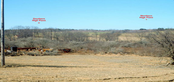
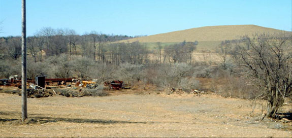
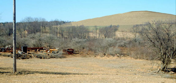
Station 9
-

Station 9 (original scene): Original photograph taken on 13 April 1998 (using a 35 mm camera with a 70 mm lens) indicating the position of helium balloons used to determine the location of the northern and southern high points of the landfill landform.
-
Station 9 (simulated scene): Simulation using the original 1998 site photograph and illustrating the appearance of the proposed landfill landform after 10 years of project operations.
-
Station 9 (simulated scene): Simulation using the original 1998 site photograph and illustrating the appearance of the proposed landfill landform after 20 years of project operations.
-

Station 9 (simulated scene): Simulation using the original 1998 site photograph and illustrating the appearance of the proposed landfill landform at the time of the project completion and the closeout of all landfill operations.
-
- The simulated scenes for Station 9 are from East Ava Road at a point approximately 0.6 miles south of N.Y. State Route 294 looking in a westerly direction towards the proposed landfill footprint.
Station 14
-
Station 14 (original scene): Original photograph taken on 13 April 1998 (using a 35 mm camera with a 70 mm lens) indicating the position of helium balloons used to determine the location of the northern and southern high points of the landfill landform.
-
Station 14 (simulated scene): Simulation using the original 1998 site photograph and illustrating the appearance of the proposed landfill landform after 10 years of project operations.
-
Station 14 (simulated scene): Simulation using the original 1998 site photograph and illustrating the appearance of the proposed landfill landform after 20 years of project operations.
-
Station 14 (simulated scene): Simulation using the original 1998 site photograph and illustrating the appearance of the proposed landfill landform at the time of the project completion and the closeout of all landfill operations.
-
- The simulated scenes for Station 14 are from East Ava Road at a point approximately 0.05 miles west of Gleasman Road looking in a northwesterly direction towards the proposed landfill footprint.
Station 19
-
Station 19 (original scene): Original photograph taken on 13 April 1998 (using a 35 mm camera with a 70 mm lens) indicating the position of helium balloons used to determine the location of the northern and southern high points of the landfill landform.
-
Station 19 (simulated scene): Simulation using the original 1998 site photograph and illustrating the appearance of the proposed landfill landform after 10 years of project operations.
-
Station 19 (simulated scene): Simulation using the original 1998 site photograph and illustrating the appearance of the proposed landfill landform after 20 years of project operations.
-
Station 19 (simulated scene): Simulation using the original 1998 site photograph and illustrating the appearance of the proposed landfill landform at the time of the project completion and the closeout of all landfill operations.
-
- The simulated scenes for Station 19 are from East Ava Road at a point approximately 1.2 miles west of Gleasman Road looking in a northeasterly direction towards the proposed landfill footprint.
Station 22
-
Station 22 (original scene): Original photograph taken on 13 April 1998 (using a 35 mm camera with a 70 mm lens) indicating the position of helium balloons used to determine the location of the northern and southern high points of the landfill landform.
-
Station 22 (simulated scene): Simulation using the original 1998 site photograph and illustrating the appearance of the proposed landfill landform after 10 years of project operations.
-
Station 22 (simulated scene): Simulation using the original 1998 site photograph and illustrating the appearance of the proposed landfill landform after 20 years of project operations.
-
Station 22 (simulated scene): Simulation using the original 1998 site photograph and illustrating the appearance of the proposed landfill landform at the time of the project completion and the closeout of all landfill operations.
-
- The simulated scenes for Station 22 are from Gleasman Road at a point approximately 1.0 mile north of East Ava Road looking in a westerly direction towards the proposed landfill footprint.
Station 24
-
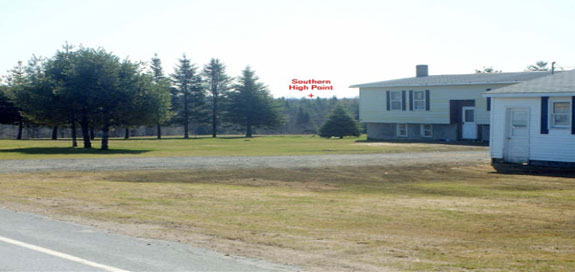
Station 24 (original scene): Original photograph taken on 13 April 1998 (using a 35 mm camera with a 70 mm lens). The helium balloons used to determine the location of the high points of the landfill are not viewable from this location.
-
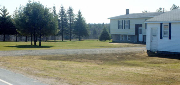
Station 24 (simulated scene): Simulation using the original 1998 site photograph and illustrating the appearance of the proposed landfill landform after 10 years of project operations. Note - the landfill is not visible in this scene.
-

Station 24 (simulated scene): Simulation using the original 1998 site photograph and illustrating the appearance of the proposed landfill landform after 20 years of project operations. Note - the landfill is barely visible in this scene.
-
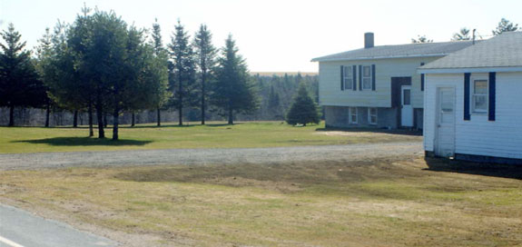
Station 24 (simulated scene): Simulation using the original 1998 site photograph and illustrating the appearance of the proposed landfill landform at the time of the project completion and the closeout of all landfill operations.
-
- The simulated scenes for Station 24 are from N.Y. State Route 294 approximately 0.75 miles east of N.Y. State Route 26 looking in a southeasterly direction towards the proposed landfill footprint.
Station 25
-
Station 25 (original scene): Original photograph taken on 13 April 1998 (using a 35 mm camera with a 70 mm lens). The helium balloons used to determine the location of the high points of the landfill are not viewable from this location.
-
Station 25 (simulated scene): Simulation using the original 1998 site photograph and illustrating the appearance of the proposed landfill landform after 10 years of project operations. Note - the landfill is not visible in this scene.
-
Station 25 (simulated scene): Simulation using the original 1998 site photograph and illustrating the appearance of the proposed landfill landform after 20 years of project operations. Note - the landfill is barely visible in this scene.
-

Station 25 (simulated scene): Simulation using the original 1998 site photograph and illustrating the appearance of the proposed landfill landform at the time of the project completion and the closeout of all landfill operations.
-
- The simulated scenes for Station 25 are from County Route 46 approximately 0.1 mile west of Mud Lake Road looking in an easterly direction towards the proposed landfill footprint.
Station 26
-
Station 26 (original scene): Original photograph taken on 13 April 1998 (using a 35 mm camera with a 70 mm lens) indicating the position of the helium balloon used to determine the location of the northern high point of the landfill landform.
-
Station 26 (simulated scene): Simulation using the original 1998 site photograph and illustrating the appearance of the proposed landfill landform after 10 years of project operations. Note - the landfill is not visible in this scene.
-
Station 26 (simulated scene): Simulation using the original 1998 site photograph and illustrating the appearance of the proposed landfill landform after 20 years of project operations.
-
Station 26 (simulated scene): Simulation using the original 1998 site photograph and illustrating the appearance of the proposed landfill landform at the time of the project completion and the closeout of all landfill operations.
-
- The simulated scenes for Station 26 are from Golden Road approximately 0.85 miles east of N.Y. State Route 26 looking in a southeasterly direction towards the proposed landfill footprint.